Quick Reference
Painted in early "33
Ashfield, MA
Oil on Canvas
Landscape
Farms
36" x 42"
Northfield Seminary, 1933
Williston Academy, 1933
Deerfield Academy, 1935
Myles Standish Hotel, 1935-'36
Deerfield Valley Artist Assoc., 1941
Hotel Weldon,(Greenfld., MA) 1945
Newton Savings Bank, 1947
Newton Savings Bank
N/A
.png)
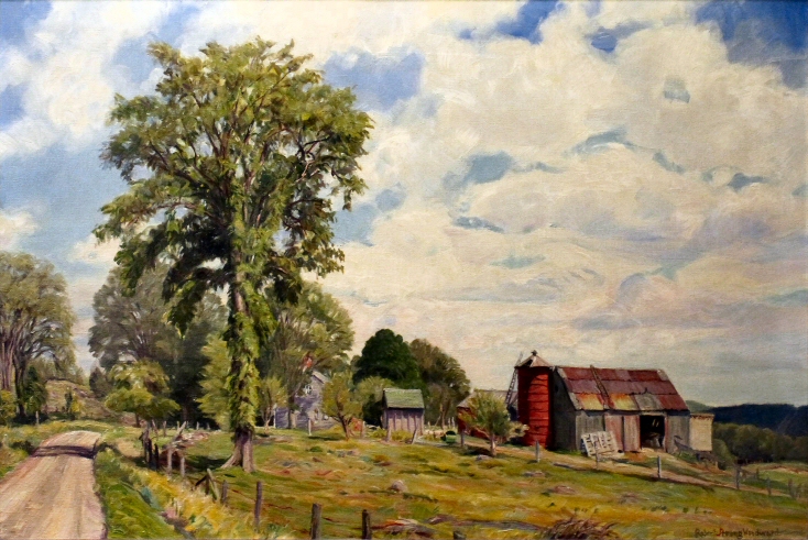
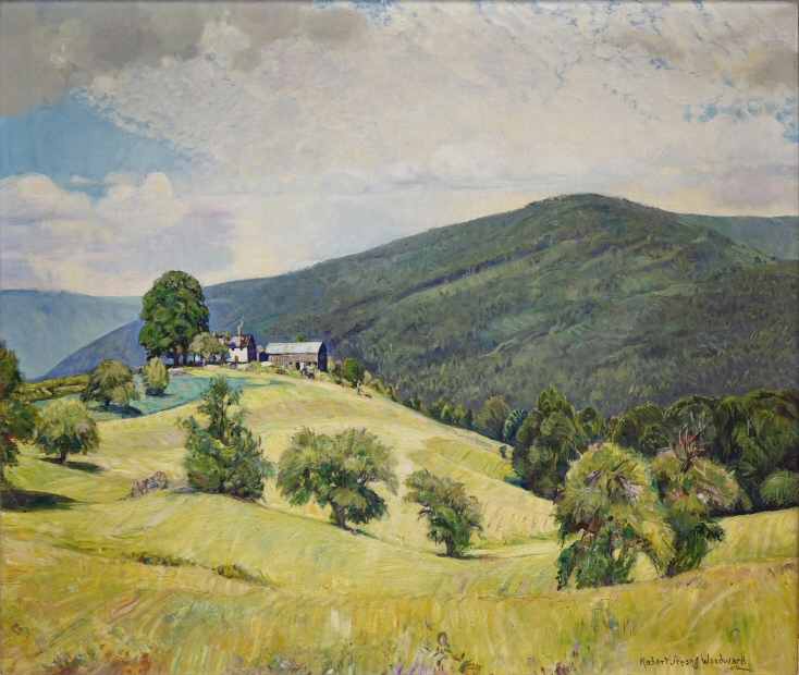
Featured Artwork: September Peace, 1933
HOWEVER WE ARE CERTAIN IT IS
THE SAME SUBJECT SEEN BELOW...
If you have any information regarding this artwork, please
contact us
RSW's Diary Comments
734.png?url=photos/september_peace1918(26)734.png)
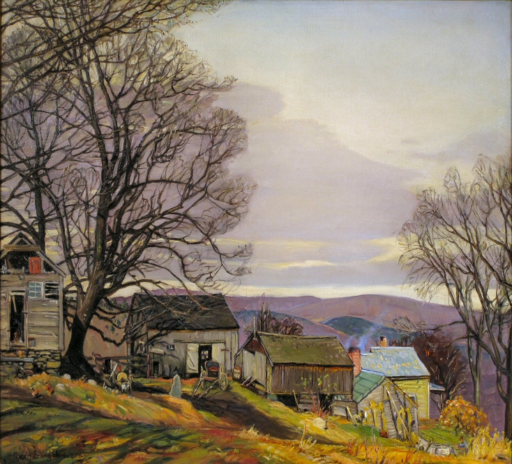
 September Peace, 1918: the 27" x 30" canvas
referred to by RSW in the dairy entry for the 36" x 42",
1933 painting. They share the same name confirmed
by Dr. Lunt, the 1918 painting buyer and RSW friend.
"Painted in early '33. A view on the "Brown Farm" (once owned by Uncle Bert) just off the Apple Valley Road. I made a smaller 27" x 30" of this same subject which went to J. H. Miller Co., Springfield, in a lot of a dozen canvases of mine they bought early in my oil-painting career. This larger canvas (36" x 42") was painted partially from the older canvas but also taken out to the farm itself to be worked on. Sold Nov.1947, through Earl Perry to Newton Savings Bank, Newton, Mass."
Editor's Note:
Traditionally we always used the 1918 painting, September Peace, it illustrate
the subject of this the 1933 painting. We are no longer going to do this for paintings we actually do not
have pictures for because it begins to get confusing.
Furthermore, in the painting diary entry
above Woodward makes it clear that the '33 painting is only partially made from the 1918 painting and
that he returned to the farm to paint en plein air. Woodward's method and style of painting changed
exponentially in just the first few years of painting so imagine the difference fifteen years would be.
There is probably no similarities than the subject. Also, we feel that if Woodward still had the 1918
painting and that he wasn't forced to sell the six painting wholesale to J.H. Miller during the brief
depression of 1921 to buy the supplies he needed to make 50 painting for the MacBeth Gallery in New
York City... He would have made the 1933 canvas and possibly destroyed the 1918 one as he often did
once he found his style. Almost all of his "re-paints" where of paintings from the early 1920s. Note
that Woodward kept this paintings for another 14 years after he painted it. It was a memory to him...
⮟ Below we selected two 1933 paintings as a contrast to the 1918 style ⮟
Bonus Material
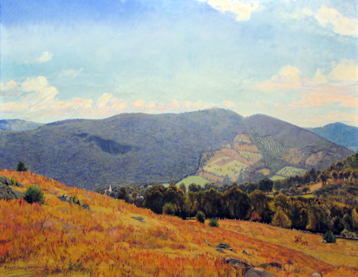
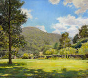
Mary Lyon's Hill, 1935: This painting is from the
other side of town and the Wilder pasture on Purinton
Hill. Still, it clearly shows the twin peaks, one 200
feet lower than the other. This perspective is north
of Apple Valley Road which starts in Ashfield, MA.
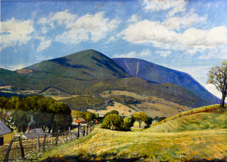
Looking at this scene from the 1918 painting, as if for the first time. We noticed the
hills in the distance... It occurred to us that what we are looking at is the twin peaks of Mary
Lyon Hill! We check out Google's topographical map and sure enough, it was possible because Apple
Valley Road does creep back into Buckland, especially where it meets Cemetery Road. We cannot look
up where Bert Wells previous farm was located because there are no records prior to 1900 available
online.
The problem is that Apple Valley Road never goes high enough or is over far enough
to see past Drake Hill. However, looking at a topographical map from the time period where the
elevations are clearly marked; Cemetery Road climbs higher than Drake Hill and Mary Lyon Hill.
According to this map, the highest point just off Cemetery Road is 106ft higher than Drake and 30ft
higher than Mary Lyon Hill.
When you take that spot and draw a line to Mary Lyon Hill. It
is a straight line point of view. In fact, looking at the map below, the peak of Drake Hill is to the
north indicating that the hill is a hundred or more feet lower. The ridge line you see in the painting
above is believed to be Ridge Hill on the Buckland-Ashfield line. We will continue to investigate this
information by going to the Franklin County building in Greenfield to see if we can locate the exact
property Bert Wells owned.
